Plate tectonics
This article is about the scientific theory describing the large-scale motion of seven large plates and the movements of a larger number of smaller plates of Earth's lithosphere.
| Plate Tectonics | |
|---|---|
|
|
| Key proponents | Alfred Wegener (Continental Drift) Harry Hess (Seafloor Spreading) John Tuzo Wilson Dan McKenzie |
| Established | 1912 (Continental Drift) 1960s (Plate Tectonics) |
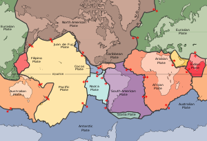
| Major Plates | African, Antarctic, Eurasian, Indo-Australian, North American, Pacific, South American |
Plate tectonics is the scientific theory that describes the large-scale motion of the plates making up Earth's lithosphere. The model builds on the concept of continental drift, an idea developed during the first few decades of the 20th century. The geoscientific community accepted plate-tectonic theory after seafloor spreading was validated in the late 1950s and early 1960s.
The lithosphere, which is the rigid outermost shell of a planet (the crust and upper mantle), is broken into seven or eight major plates (depending on how they are defined) and many minor plates. Where the plates meet, their relative motion determines the type of boundary: convergent, divergent, or transform. Earthquakes, volcanic activity, mountain-building, and oceanic trench formation occur along these plate boundaries (or faults). The relative movement of the plates typically ranges from zero to 100 mm annually.
Contents
History of the theory [edit]
Continental drift [edit]
In 1912, the German meteorologist Alfred Wegener published his theory of continental drift. He hypothesized that the continents were once joined together in a single "supercontinent" called Pangea (from Ancient Greek for "all lands"). Wegener based his theory on several lines of evidence:
- Jigsaw fit: The coastlines of South America and Africa appear to fit together like puzzle pieces.
- Fossil evidence: Identical fossils of plants (e.g., Glossopteris) and animals (e.g., Mesosaurus) were found on continents now separated by wide oceans.
- Geological match: Rock formations and mountain ranges on different continents matched in age and composition.
- Paleoclimatic data: Evidence of past glaciation was found in tropical regions of India and Africa.
Despite the evidence, Wegener's theory was largely rejected by the scientific community because he could not provide a convincing mechanism for how the continents moved. He suggested that the continents plowed through the oceanic crust, driven by centrifugal forces or tidal influence, which physicists proved to be mathematically impossible.
Seafloor spreading [edit]
In the 1950s and 1960s, new technology allowed scientists to map the ocean floor. They discovered the Mid-Atlantic Ridge, a massive underwater mountain range. Harry Hess proposed the theory of seafloor spreading in 1960. He suggested that new oceanic crust is created at mid-ocean ridges and moves away from them, eventually sinking back into the mantle at deep-sea trenches.
Evidence for this came from paleomagnetism. As magma cools at the ridges, magnetic minerals align with Earth's magnetic field. Because the Earth's magnetic poles flip periodically, the ocean floor shows a pattern of "magnetic stripes" that are symmetrical on either side of the ridge. This provided the "conveyor belt" mechanism that Wegener’s theory lacked.
Key principles [edit]
The outer layer of the Earth is divided into the lithosphere and the asthenosphere. This division is based on mechanical properties rather than chemical composition.
- Lithosphere
- The cool, rigid outer layer of the Earth. It includes the crust and the uppermost part of the mantle. It is broken into tectonic plates.
- Asthenosphere
- The highly viscous, mechanically weak, and ductilely deforming region of the upper mantle which lies just below the lithosphere. It allows the plates above it to move.
Types of plate boundaries [edit]
Three types of plate boundaries exist, characterized by the way the plates move relative to each other.
| Boundary Type | Motion | Topographic Features | Example |
|---|---|---|---|
| Divergent | Spreading (moving apart) | Mid-ocean ridge, rift valley | Mid-Atlantic Ridge, East African Rift |
| Convergent | Subduction or Collision | Trench, mountain range, volcanic arc | Andes Mountains, Himalayas, Mariana Trench |
| Transform | Lateral sliding | Fault lines | San Andreas Fault |
Convergent boundaries
Convergent boundaries occur where two plates slide toward each other. There are three subtypes:
- Oceanic-Continental: The denser oceanic plate sinks beneath the continental plate in a process called subduction. This creates volcanic mountain ranges (e.g., the Andes).
- Oceanic-Oceanic: One oceanic plate subducts under the other, forming a deep-sea trench and an island arc (e.g., Japan or the Aleutian Islands).
- Continental-Continental: Neither plate is dense enough to subduct. Instead, the crust buckles and is pushed upward, creating massive mountain ranges (e.g., the Himalayas).
Driving forces of plate motion [edit]
Scientists generally agree that several forces contribute to the movement of tectonic plates. While mantle convection was originally thought to be the primary driver, modern research highlights the importance of gravitational forces acting on the plates themselves.
- Slab Pull: The primary force. As an old, cold oceanic plate subducts, its weight pulls the rest of the plate along behind it.
- Ridge Push: Gravity causes the elevated lithosphere at a mid-ocean ridge to slide down the flanks of the ridge, pushing the plate away.
- Mantle Convection: The slow, creeping motion of Earth's solid silicate mantle caused by convection currents carrying heat from the interior to the surface.
Supercontinent cycle [edit]
Plate tectonics is a cyclic process. Over hundreds of millions of years, continents aggregate into supercontinents and then break apart again. This is known as the Wilson Cycle.
"The history of the Earth is a history of change, where the very ground beneath our feet is in a constant state of flux, driven by the heat of the core and the laws of physics."
The most famous supercontinent is Pangea, which existed approximately 335 to 175 million years ago. However, there were earlier supercontinents, such as Rodinia (roughly 1 billion years ago) and Columbia (roughly 1.8 to 1.5 billion years ago). Geologists predict that in another 250 million years, the continents will once again merge into a new supercontinent, often referred to as Pangea Proxima or Amasia.
Summary of Major Plates
- Pacific Plate: The largest tectonic plate, mostly underlying the Pacific Ocean.
- North American Plate: Covers most of North America, Greenland, and parts of the Atlantic and Arctic Oceans.
- Eurasian Plate: Consists of most of Europe and Asia.
- African Plate: Includes the continent of Africa and surrounding oceanic crust.
- Antarctic Plate: Centered on the South Pole.
- Indo-Australian Plate: Often considered two separate plates (Indian and Australian) that move together.
- South American Plate: Covers South America and the western Atlantic.
Modern measurements of plate motion are conducted using Global Positioning System (GPS) technology and Very Long Baseline Interferometry (VLBI), allowing scientists to track continental movement with millimeter-level precision in real-time.
Generation[edit]
| Provider | gemini |
|---|---|
| Model | gemini-3-flash-preview |
| Generated | 2026-03-20 21:40:22 UTC |
| Seed source | curated (geology) |
| Seed | Plate tectonics and continental drift theory |